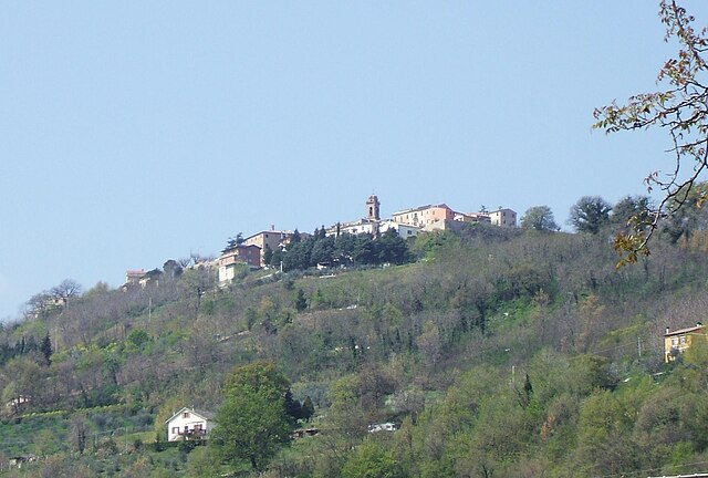
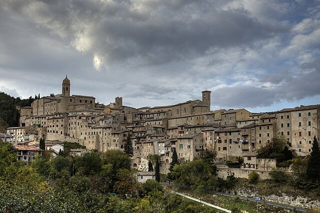
Arcevia (Arcevia)
.svg)
- Italian comune
 Hiking in Arcevia
Arcevia, located in the Marche region of Italy, is an excellent destination for hiking enthusiasts. The area is renowned for its beautiful landscapes, medieval villages, and rich history. Here are some key points to consider if you're planning a hiking adventure in Arcevia:
Scenic Trails
-
Nature Trails: The hills surrounding Arcevia offer a variety of trails that meander through picturesque vineyards, olive groves, and dense forests. Popular routes include those that connect to the scenic hills of the surrounding countryside.
-
Natural Reserves: The nearby Gola della Rossa e di Frasassi Natural Park features numerous trails ranging from easy walks to more challenging treks. You'll find diverse flora and fauna along these paths, as well as breathtaking views.
-
Historical Routes: Many trails lead through historic sites, including ancient churches, castles, and medieval ruins. Incorporating some historical exploration into your hike can provide a richer experience.
Difficulty Levels
- The trails in Arcevia range from easy to moderately challenging, making it accessible for hikers of all skill levels. Beginners can enjoy leisurely walks, while more experienced hikers can seek out steeper paths that offer greater views and adventure.
Best Time to Hike
- The ideal hiking months are typically spring (April to June) and fall (September to October) when temperatures are pleasant, and the countryside is alive with color. Summer can be quite hot, while winter may bring snow to higher elevations.
Local Amenities
- Arcevia has sufficient amenities, including local accommodations, restaurants, and shops to stock up on supplies. It's advisable to carry enough water and snacks when hiking, especially on longer trails.
Safety Tips
- Always check weather conditions before heading out, and inform someone about your hiking plans.
- A good map or a navigation app can be very helpful. Some trails may not be well-marked.
- Wear appropriate footwear and clothing, as trails can vary in terrain and conditions.
Conclusion
Hiking in Arcevia can be a memorable experience with its combination of stunning landscapes, rich culture, and history. Whether you are seeking a solitary walk through nature or a more adventurous climb, Arcevia has something to offer for every hiking enthusiast. Always remember to respect the environment and follow local guidelines while exploring. Enjoy your hike!
- Country:

- Postal Code: 60011
- Local Dialing Code: 0731
- Licence Plate Code: AN
- Coordinates: 43° 29' 0" N, 12° 56' 23" E


- GPS tracks (wikiloc): [Link]
- AboveSeaLevel: 535 м m
- Area: 128.33 sq km
- Population: 4496
- Web site: http://arceviaweb.eu
- Wikipedia en: wiki(en)
- Wikipedia: wiki(it)
- Wikidata storage: Wikidata: Q123540
- Wikipedia Commons Gallery: [Link]
- Wikipedia Commons Category: [Link]
- Freebase ID: [/m/0gl5g8]
- GeoNames ID: Alt: [6536775]
- VIAF ID: Alt: [142006427]
- OSM relation ID: [49126]
- archINFORM location ID: [7196]
- UN/LOCODE: [ITAVR]
- ISTAT ID: 042003
- Italian cadastre code: A366
Shares border with regions:


Barbara, Marche
- Italian comune
Hiking in Barbara, Marche
Hiking in Barbara, a charming town in the Marche region of Italy, offers a wonderful blend of natural beauty, cultural heritage, and diverse hiking trails. The area is characterized by rolling hills, vineyards, olive groves, and panoramic views of the surrounding countryside....
- Country:
- Postal Code: 60010
- Local Dialing Code: 071
- Licence Plate Code: AN
- Coordinates: 43° 34' 51" N, 13° 1' 29" E
- GPS tracks (wikiloc): [Link]
- AboveSeaLevel: 219 м m
- Area: 11.04 sq km
- Population: 1335
- Web site: [Link]


Castelleone di Suasa
- Italian comune
Hiking in Castelleone di Suasa
Castelleone di Suasa is a charming town in the Marche region of Italy, located within a picturesque countryside that is ideal for hiking enthusiasts. The area is known for its rolling hills, rich history, and stunning natural landscapes, making it a great destination for outdoor activities, including hiking....
- Country:
- Postal Code: 60010
- Local Dialing Code: 071
- Licence Plate Code: AN
- Coordinates: 43° 36' 27" N, 12° 58' 35" E
- GPS tracks (wikiloc): [Link]
- AboveSeaLevel: 206 м m
- Area: 15.92 sq km
- Population: 1605
- Web site: [Link]


Genga
- Italian comune
Hiking in Genga
Genga, located in the Marche region of Italy, is a fantastic destination for hiking enthusiasts. The area is known for its stunning natural landscapes, including rugged hills, lush forests, and dramatic caves, making it an excellent location for both casual walkers and more experienced hikers....
- Country:
- Postal Code: 60040
- Local Dialing Code: 0732
- Licence Plate Code: AN
- Coordinates: 43° 25' 50" N, 12° 56' 8" E
- GPS tracks (wikiloc): [Link]
- AboveSeaLevel: 320 м m
- Area: 73.16 sq km
- Population: 1748
- Web site: [Link]
Mergo
- Italian comune
Hiking in Mergo
Mergo, a municipality located in the Marche region of Italy, offers a range of beautiful hiking opportunities primarily through its lush landscapes, rolling hills, and scenic views. The region is characterized by its rich natural biodiversity and picturesque countryside, making it a great spot for both novice and experienced hikers. Here are some highlights for hiking in Mergo:...
- Country:
- Postal Code: 60030
- Local Dialing Code: 0731
- Licence Plate Code: AN
- Coordinates: 43° 28' 20" N, 13° 2' 13" E
- GPS tracks (wikiloc): [Link]
- AboveSeaLevel: 368 м m
- Area: 7.28 sq km
- Population: 1008
- Web site: [Link]


Montecarotto
- Italian comune
Hiking in Montecarotto
Montecarotto, located in the Marche region of Italy, is a beautiful destination for hiking enthusiasts. This charming town is surrounded by picturesque landscapes, rolling hills, vineyards, and olive groves, providing a fantastic backdrop for outdoor activities. Here are some highlights and tips for hiking in Montecarotto:...
- Country:
- Postal Code: 60036
- Local Dialing Code: 0731
- Licence Plate Code: AN
- Coordinates: 43° 31' 35" N, 13° 3' 52" E
- GPS tracks (wikiloc): [Link]
- AboveSeaLevel: 385 м m
- Area: 24.39 sq km
- Population: 1920
- Web site: [Link]

Rosora
- Italian comune
Hiking in Rosora
Rosora is a charming town located in the Marche region of Italy, surrounded by picturesque landscapes and rolling hills. It offers several hiking opportunities for outdoor enthusiasts who wish to explore the natural beauty of the area....
- Country:
- Postal Code: 60030
- Local Dialing Code: 0731
- Licence Plate Code: AN
- Coordinates: 43° 28' 58" N, 13° 4' 9" E
- GPS tracks (wikiloc): [Link]
- AboveSeaLevel: 381 м m
- Area: 9.41 sq km
- Population: 1956
- Web site: [Link]


Sassoferrato
- Italian comune
Hiking in Sassoferrato
Sassoferrato, located in the Marche region of Italy, is a fantastic destination for hiking enthusiasts. The area is characterized by its stunning natural landscapes, rich history, and diverse trails that cater to a variety of skill levels. Here are some key highlights about hiking in Sassoferrato:...
- Country:
- Postal Code: 60041
- Local Dialing Code: 0732
- Licence Plate Code: AN
- Coordinates: 43° 25' 39" N, 12° 51' 23" E
- GPS tracks (wikiloc): [Link]
- AboveSeaLevel: 386 м m
- Area: 137.23 sq km
- Population: 7104
- Web site: [Link]


Serra de' Conti
- Italian comune
Hiking in Serra de' Conti
Serra de' Conti is a charming area in the Marche region of Italy, known for its picturesque landscapes, rolling hills, and rich cultural heritage. Here are some insights into hiking in this region:...
- Country:
- Postal Code: 60030
- Local Dialing Code: 0731
- Licence Plate Code: AN
- Coordinates: 43° 32' 32" N, 13° 2' 16" E
- GPS tracks (wikiloc): [Link]
- AboveSeaLevel: 261 м m
- Area: 24.54 sq km
- Population: 3769
- Web site: [Link]

Serra San Quirico
- Italian comune
Hiking in Serra San Quirico
Serra San Quirico is a charming village located in the Marche region of Italy, surrounded by beautiful landscapes and offers numerous opportunities for hiking enthusiasts. Here are some key points to consider when hiking in this area:...
- Country:
- Postal Code: 60048
- Local Dialing Code: 0731
- Licence Plate Code: AN
- Coordinates: 43° 26' 52" N, 13° 0' 55" E
- GPS tracks (wikiloc): [Link]
- AboveSeaLevel: 300 м m
- Area: 49.33 sq km
- Population: 2744
- Web site: [Link]


Pergola, Marche
- Italian comune
Hiking in Pergola, Marche
Pergola, located in the Marche region of Italy, is a charming town nestled in the rolling hills and surrounded by beautiful landscapes, making it an excellent destination for hiking enthusiasts. Here are some highlights about hiking in the area:...
- Country:
- Postal Code: 61045
- Local Dialing Code: 0721
- Licence Plate Code: PU
- Coordinates: 43° 33' 51" N, 12° 50' 5" E
- GPS tracks (wikiloc): [Link]
- AboveSeaLevel: 265 м m
- Area: 112.4 sq km
- Population: 6200
- Web site: [Link]


San Lorenzo in Campo
- Italian comune
Hiking in San Lorenzo in Campo
San Lorenzo in Campo is a charming town located in the Marche region of Italy, known for its beautiful landscapes, rich history, and outdoor activities, including hiking. The surrounding area offers a variety of trails suitable for different skill levels, allowing hikers to explore the natural beauty of the region....
- Country:
- Postal Code: 61047
- Local Dialing Code: 0721
- Licence Plate Code: PU
- Coordinates: 43° 36' 18" N, 12° 56' 46" E
- GPS tracks (wikiloc): [Link]
- AboveSeaLevel: 209 м m
- Area: 28.8 sq km
- Population: 3358
- Web site: [Link]