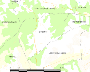
Chalon (Chalon)
- commune in Isère, France
Chalon, located in the Isère department of the Auvergne-Rhône-Alpes region in southeastern France, is surrounded by beautiful natural landscapes that offer various hiking opportunities. Here are some highlights of hiking in the area:
Trails and Routes
-
Nearby Mountains: The region features stunning mountain ranges such as the Vercors and the Chartreuse, where you can find numerous hiking trails suitable for all levels, from easy walks to more challenging climbs.
-
Marked Hiking Paths: There are established trails with marked paths, making navigation easier. The Vercors Regional Natural Park, in particular, has a wide network of trails that showcase its unique geological formations and diverse ecosystems.
-
Lakes and Rivers: Many trails lead to beautiful spots around lakes and rivers, offering picturesque views and opportunities for wildlife observation.
Key Hiking Areas
- Vercors Regional Natural Park: This area features dramatic cliffs, deep gorges, and rich biodiversity. Routes vary from short day hikes to longer treks.
- Chartreuse Mountains: Known for their lush forests and rugged terrain, this area provides numerous hiking options, including routes that lead to panoramic viewpoints.
Seasonal Considerations
- Spring and Summer: Ideal for hiking, with temperate weather and blooming flora. Be mindful of potential heat and ensure adequate hydration.
- Autumn: Offers beautiful fall foliage, especially in October. The weather is generally mild, but be prepared for variable conditions.
- Winter: Hiking can still be enjoyed, particularly in lower elevations, but conditions may require snow shoes or crampons in higher terrains.
Tips for Hikers
- Check Trail Conditions: Always check current trail conditions before setting out.
- Prepare Adequately: Bring appropriate gear, including sturdy hiking shoes, a map or GPS, and sufficient water and snacks.
- Local Regulations: Respect local wildlife and follow any specific regulations regarding hiking in protected areas.
Additional Activities
Beyond hiking, the region offers opportunities for climbing, cycling, and winter sports, giving visitors a chance to experience the varied landscapes year-round.
Whether you're a novice hiker or an experienced adventurer, Chalon and the surrounding Isère region provide a wonderful backdrop for outdoor activities!
- Country:

- Postal Code: 38122
- Coordinates: 45° 26' 46" N, 4° 55' 53" E


- GPS tracks (wikiloc): [Link]
- Area: 5.2 sq km
- Population: 176
- Web site: http://mairie.chalon.free.fr
- Wikipedia en: wiki(en)
- Wikipedia: wiki(fr)
- Wikidata storage: Wikidata: Q1003011
- Wikipedia Commons Category: [Link]
- Freebase ID: [/m/03nvg8n]
- GeoNames ID: Alt: [3027490]
- SIREN number: [213800667]
- INSEE municipality code: 38066
Shares border with regions:


Les Côtes-d'Arey
- commune in Isère, France
- Country:

- Postal Code: 38138
- Coordinates: 45° 27' 21" N, 4° 52' 1" E


- GPS tracks (wikiloc): [Link]
- Area: 24.31 sq km
- Population: 1983


Vernioz
- commune in Isère, France
Vernioz, located in the Auvergne-Rhône-Alpes region of France, is a charming destination for hikers. Nestled in the foothills of the Massif Central, it offers a scenic landscape with various trails suited for different skill levels and preferences....
- Country:

- Postal Code: 38150
- Coordinates: 45° 25' 19" N, 4° 54' 19" E


- GPS tracks (wikiloc): [Link]
- Area: 11.32 sq km
- Population: 1236
- Web site: [Link]


Saint-Sorlin-de-Vienne
- commune in Isère, France
 Hiking in Saint-Sorlin-de-Vienne
Saint-Sorlin-de-Vienne is a charming commune located in the Auvergne-Rhône-Alpes region of France, offering a variety of hiking opportunities in a picturesque setting. Here are some highlights about hiking in this area:...
- Country:

- Postal Code: 38200
- Coordinates: 45° 28' 4" N, 4° 56' 34" E


- GPS tracks (wikiloc): [Link]
- AboveSeaLevel: 362 м m
- Area: 9.94 sq km
- Population: 863


Montseveroux
- commune in Isère, France
Montseveroux is a beautiful area for hiking, located in the French Alps, specifically in the Isère department. The region is known for its stunning natural scenery, diverse landscapes, and the variety of trails suitable for different skill levels....
- Country:

- Postal Code: 38122
- Coordinates: 45° 25' 44" N, 4° 58' 15" E


- GPS tracks (wikiloc): [Link]
- Area: 16.48 sq km
- Population: 954
- Web site: [Link]


Monsteroux-Milieu
- commune in Isère, France
Monsteroux-Milieu, located in the Isère department of the Auvergne-Rhône-Alpes region in France, is a fantastic destination for hiking enthusiasts. The area is known for its stunning natural landscapes, diverse terrain, and a variety of trails suited for different levels of hikers. Here are some key points to know about hiking in Monsteroux-Milieu:...
- Country:

- Postal Code: 38122
- Coordinates: 45° 25' 56" N, 4° 56' 12" E


- GPS tracks (wikiloc): [Link]
- Area: 8.17 sq km
- Population: 785
