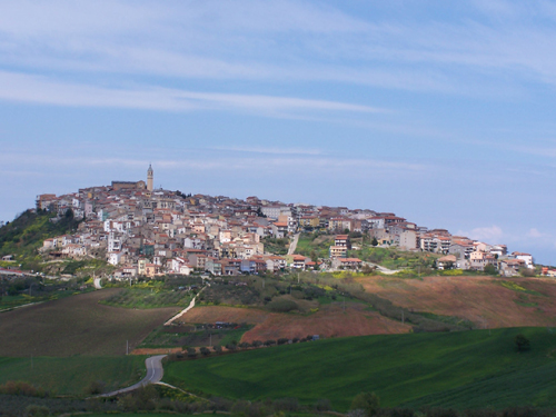
Guglionesi (Guglionesi)
.svg)
- Italian comune
 Hiking in Guglionesi
Guglionesi is a charming village located in the Molise region of Italy, surrounded by beautiful countryside and rolling hills, making it a great destination for hiking enthusiasts. Here's what you can expect when hiking in and around Guglionesi:
1. Scenic Trails
The area offers various hiking trails that showcase the stunning landscapes typical of the Molise region, including olive groves, vineyards, and panoramic views of the surrounding mountains and valleys.
2. Historical Insights
As you hike, you'll have the chance to explore the rich history of the region. Guglionesi itself has a historic center with picturesque architecture, and you may come across ancient ruins and medieval structures along your trails.
3. Flora and Fauna
Hiking in Guglionesi allows you to experience diverse flora and fauna. The region is home to various plant species, wildlife, and birdwatching opportunities, which can make your hike even more enriching.
4. Local Culture
The trails might lead you to local farms, vineyards, and small communities where you can experience the local culture, cuisine, and hospitality. Don't miss the opportunity to enjoy traditional Molisean dishes at a local trattoria.
5. Difficulty Levels
There are trails suitable for all skill levels, from easy walks for beginners and families to more challenging hikes for experienced trekkers. Make sure to choose a trail that matches your fitness and experience level.
6. Best Times to Hike
Spring (April to June) and autumn (September to October) are the ideal times to hike in Guglionesi due to mild temperatures and beautiful scenery, with wildflowers in spring and vibrant fall foliage.
Tips for Hiking in Guglionesi
- Stay Hydrated: Carry enough water, especially during warmer months.
- Footwear: Wear comfortable, sturdy hiking boots or shoes suitable for uneven terrain.
- Navigation: Although many trails are well-marked, having a map or GPS can be helpful.
- Local Guidance: Consider joining a local guide or hiking group for insights into the area's natural and cultural history.
Whether you're looking for a leisurely stroll or a more strenuous trek, hiking in Guglionesi can provide a beautiful and memorable experience in the heart of Italy.
- Country:

- Postal Code: 86034
- Local Dialing Code: 0875
- Licence Plate Code: CB
- Coordinates: 41° 55' 0" N, 14° 55' 0" E


- GPS tracks (wikiloc): [Link]
- AboveSeaLevel: 369 м m
- Area: 100.95 sq km
- Population: 5246
- Web site: http://www.comune.guglionesi.cb.it
- Wikipedia en: wiki(en)
- Wikipedia: wiki(it)
- Wikidata storage: Wikidata: Q277627
- Wikipedia Commons Category: [Link]
- Freebase ID: [/m/0bycyl]
- GeoNames ID: Alt: [6537509]
- VIAF ID: Alt: [124697817]
- OSM relation ID: [41606]
- TGN ID: [1044922]
- UN/LOCODE: [ITGUG]
- ISTAT ID: 070029
- Italian cadastre code: E259
Shares border with regions:
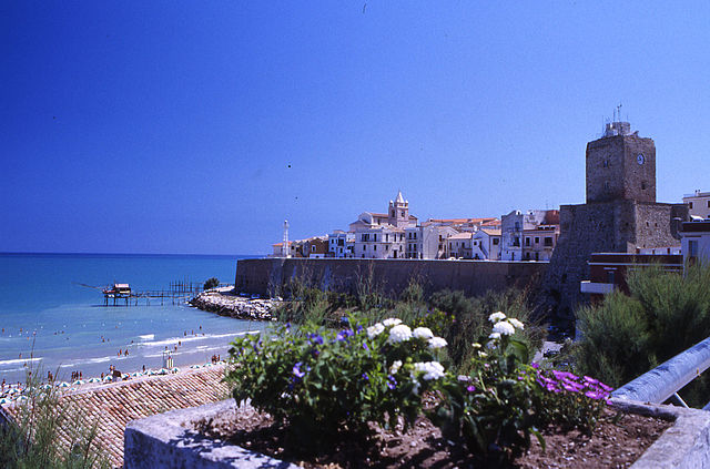

Termoli
- Italian comune
Hiking in Termoli
Termoli is a charming coastal town located in the Molise region of Italy, known for its beautiful beaches, historic architecture, and stunning views of the Adriatic Sea. While Termoli itself may not be renowned specifically for hiking, there are several opportunities for outdoor enthusiasts in the surrounding areas and nearby countryside. Here are some highlights for hiking in and around Termoli:...
- Country:
- Postal Code: 86039
- Local Dialing Code: 0875
- Licence Plate Code: CB
- Coordinates: 42° 0' 10" N, 14° 59' 41" E
- GPS tracks (wikiloc): [Link]
- AboveSeaLevel: 15 м m
- Area: 55.64 sq km
- Population: 33583
- Web site: [Link]


Campomarino
- Italian comune
Hiking in Campomarino
Campomarino is a charming coastal town located in the Molise region of Italy, known for its beautiful beaches, historical sites, and proximity to nature. While it may not be as famous for hiking as other regions in Italy, there are certainly opportunities for outdoor enthusiasts to explore the surrounding areas. Here are some aspects to consider if you're thinking about hiking in and around Campomarino:...
- Country:
- Postal Code: 86042
- Local Dialing Code: 0875
- Licence Plate Code: CB
- Coordinates: 41° 57' 24" N, 15° 2' 4" E
- GPS tracks (wikiloc): [Link]
- AboveSeaLevel: 52 м m
- Area: 76.68 sq km
- Population: 8074
- Web site: [Link]


Larino
- Italian comune
Hiking in Larino
Larino, located in the Molise region of Italy, is a small town rich in history and natural beauty, making it a charming destination for hiking enthusiasts. The surrounding area offers a variety of hiking trails that cater to different skill levels. Here are some highlights to consider when hiking in Larino:...
- Country:
- Postal Code: 86035
- Local Dialing Code: 0874
- Licence Plate Code: CB
- Coordinates: 41° 48' 0" N, 14° 55' 0" E
- GPS tracks (wikiloc): [Link]
- AboveSeaLevel: 341 м m
- Area: 88.77 sq km
- Population: 6680
- Web site: [Link]
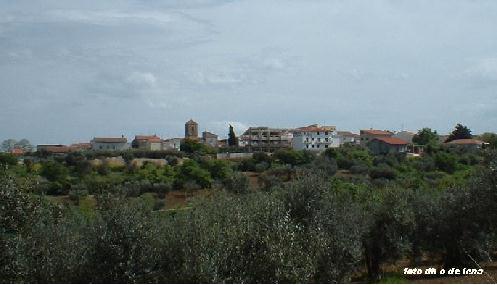
Montecilfone
- Italian comune
Hiking in Montecilfone
Montecilfone is a small village located in the Molise region of Italy, known for its stunning landscapes and natural beauty. Hiking in this area can be a delightful experience due to the picturesque views, varied terrain, and the charm of the local culture....
- Country:
- Postal Code: 86032
- Local Dialing Code: 0875
- Licence Plate Code: CB
- Coordinates: 41° 54' 0" N, 14° 50' 0" E
- GPS tracks (wikiloc): [Link]
- AboveSeaLevel: 405 м m
- Area: 22.92 sq km
- Population: 1355
- Web site: [Link]
Montenero di Bisaccia
- Italian comune
Hiking in Montenero di Bisaccia
Montenero di Bisaccia is a charming town located in the Molise region of Italy, known for its beautiful landscapes and outdoor activities, including hiking. The area offers a unique blend of rolling hills, coastal views, and rustic countryside, making it an attractive spot for hikers seeking both tranquility and scenic beauty....
- Country:
- Postal Code: 86036
- Local Dialing Code: 0875
- Licence Plate Code: CB
- Coordinates: 41° 57' 0" N, 14° 47' 0" E
- GPS tracks (wikiloc): [Link]
- AboveSeaLevel: 273 м m
- Area: 93.32 sq km
- Population: 6612
- Web site: [Link]
Palata
- Italian comune
Hiking in Palata
Palata, a small town in the Molise region of Italy, offers a scenic backdrop for hiking enthusiasts. Nestled in the Apennine Mountains, the area is characterized by rolling hills, lush forests, and captivating views. Here are some key points to consider if you're planning to hike in and around Palata:...
- Country:
- Postal Code: 86037
- Local Dialing Code: 0875
- Licence Plate Code: CB
- Coordinates: 41° 53' 16" N, 14° 47' 16" E
- GPS tracks (wikiloc): [Link]
- AboveSeaLevel: 520 м m
- Area: 43.82 sq km
- Population: 1676
- Web site: [Link]


Petacciato
- Italian comune
Hiking in Petacciato
Petacciato is a small town located in the Molise region of Italy, known for its beautiful landscapes, rolling hills, and proximity to the Adriatic Sea. Hiking in and around Petacciato can provide a wonderful experience for outdoor enthusiasts, with options for various skill levels. Here are some aspects to consider:...
- Country:
- Postal Code: 86038
- Local Dialing Code: 0875
- Licence Plate Code: CB
- Coordinates: 42° 1' 0" N, 14° 52' 0" E
- GPS tracks (wikiloc): [Link]
- AboveSeaLevel: 225 м m
- Area: 35.4 sq km
- Population: 3811
- Web site: [Link]
Portocannone
- Italian comune
Hiking in Portocannone
Portocannone is a small town located in the Molise region of Italy, known for its picturesque landscapes and proximity to both the Adriatic coast and the Apennine Mountains. While it may not be as well-known as some other hiking destinations in Italy, the area offers opportunities for outdoor enthusiasts to enjoy hiking amidst natural beauty and local culture....
- Country:
- Postal Code: 86045
- Local Dialing Code: 0875
- Licence Plate Code: CB
- Coordinates: 41° 55' 0" N, 15° 1' 0" E
- GPS tracks (wikiloc): [Link]
- AboveSeaLevel: 148 м m
- Area: 13.11 sq km
- Population: 2490
- Web site: [Link]

San Giacomo degli Schiavoni
- Italian comune
Hiking in San Giacomo degli Schiavoni
San Giacomo degli Schiavoni is a small town located in the Molise region of Italy, and while it may not be as widely known for hiking as some of the larger national parks or mountainous areas in the country, it offers a unique and beautiful landscape that can be enjoyable for hikers....
- Country:
- Postal Code: 86030
- Local Dialing Code: 0875
- Licence Plate Code: CB
- Coordinates: 41° 58' 0" N, 14° 57' 0" E
- GPS tracks (wikiloc): [Link]
- AboveSeaLevel: 169 м m
- Area: 11.08 sq km
- Population: 1406
- Web site: [Link]


San Martino in Pensilis
- Italian comune
Hiking in San Martino in Pensilis
San Martino in Pensilis is a charming municipality located in the Molise region of Italy. While it may not be as widely known for hiking as some other Italian destinations, it offers a variety of options for those looking to explore its picturesque landscapes....
- Country:
- Postal Code: 86046
- Local Dialing Code: 0875
- Licence Plate Code: CB
- Coordinates: 41° 52' 0" N, 15° 1' 0" E
- GPS tracks (wikiloc): [Link]
- AboveSeaLevel: 15 м m
- Area: 100.66 sq km
- Population: 4752
- Web site: [Link]