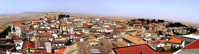
Ordona (Ordona)
.svg)
- Italian comune
 Hiking in Ordona
Ordona is a small town in the province of Foggia, Italy, and while it may not be as widely recognized for hiking as some other destinations, there are still opportunities for outdoor enthusiasts in the surrounding areas.
Hiking Opportunities:
-
National Parks Nearby: Ordona is relatively close to the Gargano National Park, which offers stunning landscapes of forests, cliffs, and the Adriatic coastline. The park features various trails suitable for different skill levels.
-
Trekking along the Tavoliere Plain: The region around Ordona, known as the Tavoliere delle Puglie, provides flat lands that are perfect for leisurely hikes. You can enjoy the vast agricultural landscapes and traditional farmhouses.
-
Local Trails: Explore local trails or paths used by farmers. These may not be formal hiking routes but can provide a unique insight into the rural life of the area.
-
Cultural and Historical Hikes: Consider a hike that includes stops at historical sites, churches, or ancient ruins in and around the town. This can provide both exercise and a cultural experience.
Preparation Tips:
- Weather: Check the weather conditions before heading out, as they can change quickly, especially in the mountainous regions.
- Gear: Wear appropriate hiking footwear, carry water, snacks, and a map. If venturing into the national parks, consider a daypack with essentials.
- Local Regulations: Ensure that you are aware of any local regulations or guidelines concerning hiking in protected areas.
Recommendations:
If you're looking for a more structured hiking experience, consider visiting an information center or local guide service in nearby larger towns, who can offer guided tours and tips on the best trails to explore.
In summary, while Ordona may not be a well-known hiking destination, there are unique opportunities to engage with the natural beauty and history of the region through hiking and exploration.
- Country:

- Postal Code: 71040
- Local Dialing Code: 0885
- Licence Plate Code: FG
- Coordinates: 41° 19' 0" N, 15° 38' 0" E


- GPS tracks (wikiloc): [Link]
- AboveSeaLevel: 120 м m
- Area: 39.57 sq km
- Population: 2843
- Web site: http://www.comune.ordona.fg.it
- Wikipedia en: wiki(en)
- Wikipedia: wiki(it)
- Wikidata storage: Wikidata: Q51938
- Wikipedia Commons Category: [Link]
- Freebase ID: [/m/076cn4]
- GeoNames ID: Alt: [6539579]
- BnF ID: [119414690]
- VIAF ID: Alt: [236811601]
- OSM relation ID: [41235]
- TGN ID: [4008241]
- Digital Atlas of the Roman Empire ID: [16751]
- Pleiades ID: [442613]
- ISTAT ID: 071063
- Italian cadastre code: M266
Shares border with regions:


Foggia
- Italian comune
Hiking in Foggia
Foggia, located in the Apulia region of southeastern Italy, offers a diverse range of hiking opportunities that cater to various skill levels and preferences. The surrounding areas are known for their rich natural beauty, historical significance, and unique landscapes....
- Country:
- Postal Code: 71121–71122
- Local Dialing Code: 0881
- Licence Plate Code: FG
- Coordinates: 41° 28' 0" N, 15° 34' 0" E
- GPS tracks (wikiloc): [Link]
- AboveSeaLevel: 76 м m
- Area: 509.26 sq km
- Population: 151975
- Web site: [Link]


Cerignola
- Italian comune
Hiking in Cerignola
Cerignola, located in the Apulia region of southern Italy, is not as widely known for hiking as some of its other Italian counterparts, but it offers beautiful landscapes and opportunities for walking and exploring nature....
- Country:
- Postal Code: 71042; 71040
- Local Dialing Code: 0885
- Licence Plate Code: FG
- Coordinates: 41° 16' 0" N, 15° 54' 0" E
- GPS tracks (wikiloc): [Link]
- AboveSeaLevel: 120 м m
- Area: 593.93 sq km
- Population: 58540
- Web site: [Link]

Ascoli Satriano
- Italian comune
Hiking in Ascoli Satriano
Ascoli Satriano, located in the Puglia region of Italy, offers a variety of hiking opportunities amidst stunning landscapes and rich cultural heritage. Here are some key points about hiking in the area:...
- Country:
- Postal Code: 71022
- Local Dialing Code: 0885
- Licence Plate Code: FG
- Coordinates: 41° 12' 56" N, 15° 33' 28" E
- GPS tracks (wikiloc): [Link]
- AboveSeaLevel: 376 м m
- Area: 336.68 sq km
- Population: 6167
- Web site: [Link]
Carapelle
- Italian comune
Hiking in Carapelle
Carapelle, a charming town in the Apulia region of Italy, offers a variety of hiking opportunities, particularly due to its proximity to the beautiful landscapes of the Gargano National Park and the coastal trails along the Adriatic Sea....
- Country:
- Postal Code: 71041
- Local Dialing Code: 0885
- Licence Plate Code: FG
- Coordinates: 41° 22' 0" N, 15° 42' 0" E
- GPS tracks (wikiloc): [Link]
- AboveSeaLevel: 62 м m
- Area: 25 sq km
- Population: 6692
- Web site: [Link]
Orta Nova
- Italian comune
Hiking in Orta Nova
Orta Nova is a charming town located in the Apulia region of southern Italy, not far from the beautiful landscapes of the Gargano National Park and the Tavoliere delle Puglie. While the town and its immediate area might not be well-known as a hiking destination, there are still opportunities for nature walks and exploring the countryside....
- Country:
- Postal Code: 71045
- Local Dialing Code: 0885
- Licence Plate Code: FG
- Coordinates: 41° 19' 51" N, 15° 42' 41" E
- GPS tracks (wikiloc): [Link]
- AboveSeaLevel: 70 м m
- Area: 105.24 sq km
- Population: 17675
- Web site: [Link]
Stornara
- Italian comune
Hiking in Stornara
Stornara, located in the Apulia region of southern Italy, is more known for its agricultural landscape than for traditional hiking trails. However, there are opportunities for walking and exploring the natural beauty of the area....
- Country:
- Postal Code: 71047
- Local Dialing Code: 0885
- Licence Plate Code: FG
- Coordinates: 41° 17' 0" N, 15° 46' 0" E
- GPS tracks (wikiloc): [Link]
- AboveSeaLevel: 74 м m
- Area: 33.86 sq km
- Population: 5802
- Web site: [Link]