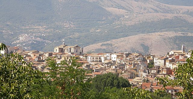
Roccacasale (Roccacasale)
.svg)
- Italian comune
 Hiking in Roccacasale
Roccacasale, located in the Abruzzo region of Italy, is a charming destination for hiking enthusiasts. The area is characterized by its stunning natural landscapes, rich biodiversity, and panoramic views of the surrounding mountains and valleys. Here are some highlights and tips for hiking in Roccacasale:
Trails and Routes
-
Local Paths: The region has numerous trails that cater to various skill levels, allowing hikers to explore lush forests, rocky terrains, and beautiful flora and fauna. Look for well-marked paths that lead to scenic viewpoints.
-
Nature Reserves: Nearby natural parks, such as the Parco Nazionale della Majella, offer extended hiking opportunities. Trails here vary from easy walks to more demanding treks, with routes often leading to breathtaking natural landmarks, waterfalls, and wildlife spotting opportunities.
-
Cultural Routes: Some trails may take you through quaint villages and historical sites, allowing hikers to engage with the local culture and enjoy the unique architecture characteristic of the region.
Best Time to Hike
- Spring and Fall: The best times for hiking in Roccacasale are spring (April to June) and fall (September to October) when temperatures are mild, and landscapes are particularly vibrant. Summer can be hot, while winter may bring snow to higher elevations, affecting trail accessibility.
Preparation and Safety
- Gear: Wear sturdy hiking boots and appropriate clothing for varying weather conditions, along with a hat and sunscreen, especially during the summer months.
- Hydration and Snacks: Carry sufficient water and snacks to keep your energy levels up during your hikes.
- Navigation: A map and/or GPS device can be very helpful, as some trails may not be well-marked. Additionally, consider downloading offline maps to ensure you don't get lost in areas with poor cell service.
Local Tips
- Visitor Centers: Stop at local visitor centers for trail maps and recommendations tailored to your interests and fitness level. They can also provide valuable insight into any special wildlife or seasonal events.
- Guided Tours: If you're new to the area, consider joining a guided hiking tour to learn more about the local ecology, history, and culture from knowledgeable locals.
Roccacasale offers a peaceful retreat for nature lovers and a fantastic way to experience the natural beauty and cultural richness of Italy. Enjoy your hiking adventure!
- Country:

- Postal Code: 67030
- Local Dialing Code: 0864
- Licence Plate Code: AQ
- Coordinates: 42° 7' 26" N, 13° 53' 20" E


- GPS tracks (wikiloc): [Link]
- AboveSeaLevel: 450 м m
- Area: 17.31 sq km
- Population: 671
- Web site: http://www.roccacasale.it/
- Wikipedia en: wiki(en)
- Wikipedia: wiki(it)
- Wikidata storage: Wikidata: Q50137
- Wikipedia Commons Category: [Link]
- Freebase ID: [/m/0fg7pz]
- GeoNames ID: Alt: [6537442]
- VIAF ID: Alt: [125711022]
- OSM relation ID: [41801]
- WOEID: [721847]
- Digital Atlas of the Roman Empire ID: [26577]
- Google Maps Customer ID: [4026475859691571895]
- ISTAT ID: 066079
- Italian cadastre code: H389
Shares border with regions:


Corfinio
- Italian comune
Hiking in Corfinio
Corfinio is a charming town located in the Abruzzo region of Italy, surrounded by stunning natural landscapes that offer a variety of hiking opportunities. Nestled on the edge of the Gran Sasso e Monti della Laga National Park, Corfinio provides a perfect base for hikers of all levels. Here are some highlights for hiking in the area:...
- Country:
- Postal Code: 67030
- Local Dialing Code: 0864
- Licence Plate Code: AQ
- Coordinates: 42° 7' 29" N, 13° 50' 33" E
- GPS tracks (wikiloc): [Link]
- AboveSeaLevel: 346 м m
- Area: 17.95 sq km
- Population: 1036
- Web site: [Link]

Pratola Peligna
- Italian comune
Hiking in Pratola Peligna
Pratola Peligna, located in the province of L’Aquila in the Abruzzo region of Italy, is a beautiful area known for its stunning landscapes and rich natural heritage. Here are some aspects to consider for hiking in this region:...
- Country:
- Postal Code: 67035
- Local Dialing Code: 0864
- Licence Plate Code: AQ
- Coordinates: 42° 5' 57" N, 13° 52' 29" E
- GPS tracks (wikiloc): [Link]
- AboveSeaLevel: 342 м m
- Area: 28.67 sq km
- Population: 7528
- Web site: [Link]


Salle, Abruzzo
- Italian comune
Hiking in Salle, Abruzzo
Salle, a charming village in the Abruzzo region of Italy, is surrounded by the stunning natural landscapes of the Majella National Park and the Gran Sasso and Monti della Laga National Park. This area offers a variety of hiking opportunities for all skill levels, featuring breathtaking views, rich biodiversity, and historical sites....
- Country:
- Postal Code: 65020
- Local Dialing Code: 085
- Licence Plate Code: PE
- Coordinates: 42° 10' 37" N, 13° 57' 35" E
- GPS tracks (wikiloc): [Link]
- AboveSeaLevel: 450 м m
- Area: 21.8 sq km
- Population: 291
- Web site: [Link]