.jpg)
Viuz-en-Sallaz (Viuz-en-Sallaz)

- commune in Haute-Savoie, France
 Hiking in Viuz-en-Sallaz
Viuz-en-Sallaz, located in the Haute-Savoie region of France, is an ideal destination for hiking enthusiasts. Nestled in the foothills of the Alps, it offers a mix of scenic landscapes, including lush forests, rolling hills, and panoramic mountain views.
Hiking Trails:
-
Local Trails: There are several marked paths that cater to various skill levels — from easy walks suitable for families to more challenging hikes for experienced trekkers. Always check local maps for trail conditions and difficulty ratings.
-
Surrounding Nature Reserves: The nearby nature reserves, including the Dranse Valley, feature trails that allow you to immerse in nature. Here, hikers can enjoy the diverse flora and fauna of the region.
-
Mont Salève: Close to Viuz-en-Sallaz, Mont Salève presents various trails that offer magnificent views of Lake Geneva and the surrounding mountains. The ascent can be challenging, but the vistas are worth the effort.
Key Recommendations:
-
Seasonal Considerations: The best time to hike in Viuz-en-Sallaz is during spring and early fall when the weather is milder and the landscapes are vibrant with wildflowers and autumn leaves.
-
Hiking Gear: Always wear proper hiking boots and clothing suitable for variable weather. Carry enough water, snacks, and a map or GPS device for navigation.
-
Local Advice: It's a good idea to check in with local tourist information centers. They can provide up-to-date trail conditions, guided tour options, and safety tips.
-
Stay Safe: Inform someone about your hiking plans, stick to marked trails, and be mindful of wildlife.
Viuz-en-Sallaz offers a wonderful balance of hiking opportunities that can satisfy both casual walkers and serious hikers. Enjoy the breathtaking alpine scenery and the tranquility of nature!
- Country:

- Postal Code: 74250
- Coordinates: 46° 8' 51" N, 6° 24' 37" E


- GPS tracks (wikiloc): [Link]
- Area: 20.99 sq km
- Population: 4206
- Wikipedia en: wiki(en)
- Wikipedia: wiki(fr)
- Wikidata storage: Wikidata: Q845822
- Wikipedia Commons Category: [Link]
- Freebase ID: [/m/03nty9l]
- GeoNames ID: Alt: [6443083]
- SIREN number: [217403112]
- BnF ID: [15274563w]
- VIAF ID: Alt: [239172367]
- WOEID: [632507]
- INSEE municipality code: 74311
Shares border with regions:
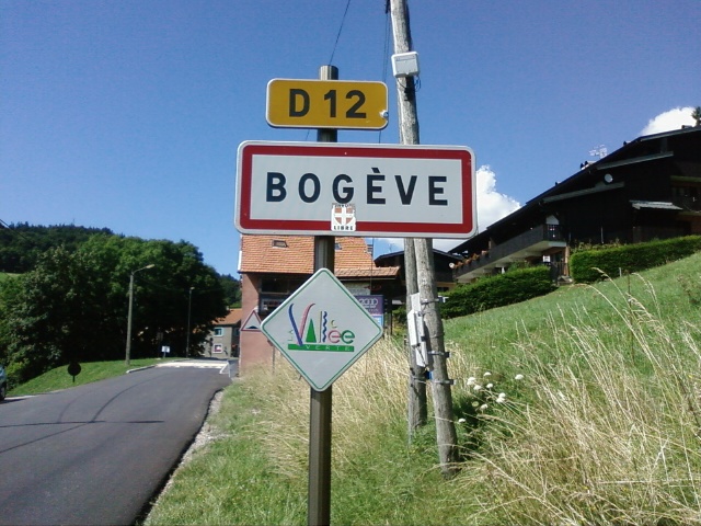

Bogève
- commune in Haute-Savoie, France
Hiking in Bogève
Bogève, a picturesque village located in the Haute-Savoie region of France, offers stunning hiking opportunities amidst the French Alps. The area is known for its rich natural beauty, characterized by rolling hills, lush forests, and breathtaking mountain views....
- Country:
- Postal Code: 74250
- Coordinates: 46° 11' 33" N, 6° 25' 47" E
- GPS tracks (wikiloc): [Link]
- Area: 7 sq km
- Population: 1046


Fillinges
- commune in Haute-Savoie, France
Hiking in Fillinges
Fillinges, located in the Haute-Savoie region of France, is a charming area that offers a variety of hiking opportunities amidst beautiful landscapes. Nestled near the French-Chevalier Mountains and close to Lake Geneva, the region provides stunning views and a mix of terrain suitable for different hiking levels....
- Country:
- Postal Code: 74250
- Coordinates: 46° 9' 30" N, 6° 20' 31" E
- GPS tracks (wikiloc): [Link]
- Area: 11.67 sq km
- Population: 3350
- Web site: [Link]

Saint-André-de-Boëge
- commune in Haute-Savoie, France
Hiking in Saint-André-de-Boëge
Saint-André-de-Boëge is a charming commune located in the Haute-Savoie department in the Auvergne-Rhône-Alpes region of southeastern France. It's nestled within the scenic backdrop of the French Alps, making it an appealing destination for outdoor enthusiasts and hikers....
- Country:
- Postal Code: 74420
- Coordinates: 46° 11' 25" N, 6° 23' 37" E
- GPS tracks (wikiloc): [Link]
- Area: 12.6 sq km
- Population: 549

Saint-Jeoire
- commune in Haute-Savoie, France
Hiking in Saint-Jeoire
Saint-Jeoire is a charming village located in the Rhône-Alpes region of France, nestled in the heart of the French Alps. It offers a variety of hiking opportunities, suitable for different skill levels and preferences. Here are some key points to consider about hiking in and around Saint-Jeoire:...
- Country:
- Postal Code: 74490
- Coordinates: 46° 8' 18" N, 6° 27' 34" E
- GPS tracks (wikiloc): [Link]
- Area: 22.75 sq km
- Population: 3252
- Web site: [Link]


Peillonnex
- commune in Haute-Savoie, France
Hiking in Peillonnex
Peillonnex, located in the Auvergne-Rhône-Alpes region of France, offers beautiful hiking opportunities with stunning views of the surrounding mountains and countryside. Here are some key points to consider when hiking in this area:...
- Country:
- Postal Code: 74250
- Coordinates: 46° 7' 53" N, 6° 22' 34" E
- GPS tracks (wikiloc): [Link]
- Area: 6.4 sq km
- Population: 1390
- Web site: [Link]


La Tour
- commune in Haute-Savoie, France
Hiking in La Tour
La Tour, located in the Haute-Savoie region of the French Alps, offers some beautiful hiking opportunities, catering to a range of skill levels from beginners to experienced hikers. Here’s an overview of what you can expect when hiking in this picturesque area:...
- Country:
- Postal Code: 74250
- Coordinates: 46° 7' 58" N, 6° 25' 50" E
- GPS tracks (wikiloc): [Link]
- Area: 7.73 sq km
- Population: 1248


Marcellaz
- commune in Haute-Savoie, France
Hiking in Marcellaz
Marcellaz is a picturesque area located in the Haute-Savoie region of France, surrounded by the stunning French Alps. It offers a variety of hiking trails that cater to different experience levels, making it a great destination for both novice and experienced hikers....
- Country:
- Postal Code: 74250
- Coordinates: 46° 8' 40" N, 6° 21' 16" E
- GPS tracks (wikiloc): [Link]
- Area: 4.17 sq km
- Population: 967


Ville-en-Sallaz
- commune in Haute-Savoie, France
Hiking in Ville-en-Sallaz
Ville-en-Sallaz is a picturesque village located in the Haute-Savoie region of southeastern France, surrounded by stunning Alpine scenery, making it an excellent starting point for various hiking adventures. Here are some highlights and tips for hiking in and around Ville-en-Sallaz:...
- Country:
- Postal Code: 74250
- Coordinates: 46° 8' 45" N, 6° 25' 20" E
- GPS tracks (wikiloc): [Link]
- Area: 3.37 sq km
- Population: 871