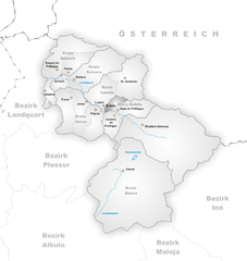
Фидерис (Fideris, Fideris)

 Hiking in Фидерис
Fideris is a picturesque village located in the canton of Graubünden in Switzerland. It's a great base for hiking enthusiasts due to its diverse trails and stunning alpine scenery. Here’s what you need to know about hiking in and around Fideris:
Trail Options
-
Fideris to the Munt Pers: This trail takes you up to Munt Pers, offering panoramic views of the surrounding mountains. The elevation gain can be moderate, making it suitable for families and less experienced hikers.
-
Val Fideris: Explore the scenic Val Fideris, where you'll find well-marked trails that pass through enchanting forests and alpine meadows. The area is known for its rich flora and fauna, particularly in spring and summer.
-
Rinderberg: A bit further afield, the trails leading to Rinderberg are worth the effort. This area may require some more experience due to steeper sections but rewards you with breathtaking views.
-
Wildlife Viewing: Keep an eye out for local wildlife, including ibex and various bird species. Early morning or late afternoon hikes are often the best times for sightings.
Tips for Hiking in Fideris
-
Trail Maps: Make sure to obtain a detailed hiking map of the area. Local tourist offices often provide information on current trail conditions and tips.
-
Weather Awareness: The weather in the Alps can change rapidly. Always check the forecast before heading out, and be prepared for rain or sudden temperature drops.
-
Gear: Good hiking boots are essential. Consider bringing poles for balance, especially if you're tackling steeper trails.
-
Food and Water: Carry enough water and snacks, particularly if you're planning a longer hike. There are limited facilities once you venture into nature.
Accessibility
Fideris is accessible by public transport, with connections to nearby towns. Do check the local timetable for train and bus availability. The village itself is quaint, with charming accommodations and places to relax after a day of hiking.
Conclusion
Hiking in Fideris offers a great blend of scenic vistas, diverse trails, and the opportunity to immerse yourself in nature. Whether you're a beginner or an expert, the area has something to offer. Just remember to respect wildlife and the natural environment during your hikes!
- Страна:

- Почтовый код: 7235
- Телефонный код: 081
- Код автомобильного номера: GR
- Координаты: 46° 53' 12" N, 9° 44' 22" E


- GPS треки (wikiloc): [Ссылка]
- Высота над уровнем моря: 1653 м m
- Площадь: 25.36 кв.км
- Население: 598
- Веб сайт: http://www.fideris.ch
- Википедия русская: wiki(ru)
- Википедия английская: wiki(en)
- Википедия национальная: wiki(de)
- Хранилище Wikidata: Wikidata: Q64643
- Катеория в википедии: [Ссылка]
- код Freebase: [/m/026f6s6]
- код GeoNames: Альт: [7285818]
- код VIAF: Альт: [241228696]
- ID отношения в OpenStreetMap: [1684077]
- код GND: Альт: [4727272-7]
- идентификатор HDS: [1572]
- код швейцарского муниципалитета: [3861]
Граничит с регионами:


Ароза
Hiking in Ароза
Arosa is a beautiful alpine resort located in Switzerland, renowned for its stunning landscapes, diverse trails, and welcoming atmosphere for hikers of all skill levels. Here’s an overview of hiking in Arosa:...
- Страна:
- Почтовый код: 7050
- Телефонный код: 081
- Код автомобильного номера: GR
- Координаты: 46° 46' 0" N, 9° 40' 1" E
- GPS треки (wikiloc): [Ссылка]
- Высота над уровнем моря: 2003 м m
- Площадь: 42.53 кв.км
- Население: 3185
- Веб сайт: [Ссылка]


Енац
Hiking in Енац
Jenaz is a charming village located in the Prättigau region of the Swiss Alps, known for its stunning natural beauty and excellent hiking opportunities. The area offers a variety of trails suitable for different skill levels, from easy walks to more challenging hikes....
- Страна:
- Почтовый код: 7233
- Телефонный код: 081
- Код автомобильного номера: GR
- Координаты: 46° 54' 23" N, 9° 42' 7" E
- GPS треки (wikiloc): [Ссылка]
- Высота над уровнем моря: 1469 м m
- Площадь: 25.91 кв.км
- Население: 1161
- Веб сайт: [Ссылка]

Кюблис
Hiking in Кюблис
Küblis, located in the Prättigau region of Switzerland, is a lovely spot for hiking enthusiasts. Nestled between the mountains and close to the Landquart River, this area offers a variety of trails that cater to different skill levels, from easy walks to more challenging hikes....
- Страна:
- Почтовый код: 7240
- Телефонный код: 081
- Код автомобильного номера: GR
- Координаты: 46° 54' 53" N, 9° 46' 27" E
- GPS треки (wikiloc): [Ссылка]
- Высота над уровнем моря: 814 м m
- Площадь: 8.14 кв.км
- Население: 853
- Веб сайт: [Ссылка]


Контерс
Hiking in Контерс
Conters im Prättigau is a charming village located in the Graubünden region of Switzerland, surrounded by stunning natural landscapes and offering various hiking opportunities. Here are some key points to consider when planning your hiking adventure in and around Conters:...
- Страна:
- Почтовый код: 7241
- Телефонный код: 081
- Код автомобильного номера: GR
- Координаты: 46° 53' 59" N, 9° 47' 0" E
- GPS треки (wikiloc): [Ссылка]
- Высота над уровнем моря: 1110 м m
- Площадь: 18.40 кв.км
- Население: 225
- Веб сайт: [Ссылка]


Луцайн
Hiking in Луцайн
Luzein is a picturesque Swiss village located in the canton of Graubünden, surrounded by stunning alpine landscapes. It’s a great destination for hiking enthusiasts, offering a diverse range of trails that cater to different skill levels. Here are some details about hiking in Luzein:...
- Страна:
- Почтовый код: 7242
- Телефонный код: 081
- Код автомобильного номера: GR
- Координаты: 46° 55' 11" N, 9° 46' 0" E
- GPS треки (wikiloc): [Ссылка]
- Высота над уровнем моря: 1892 м m
- Площадь: 31.60 кв.км
- Население: 1573
- Веб сайт: [Ссылка]